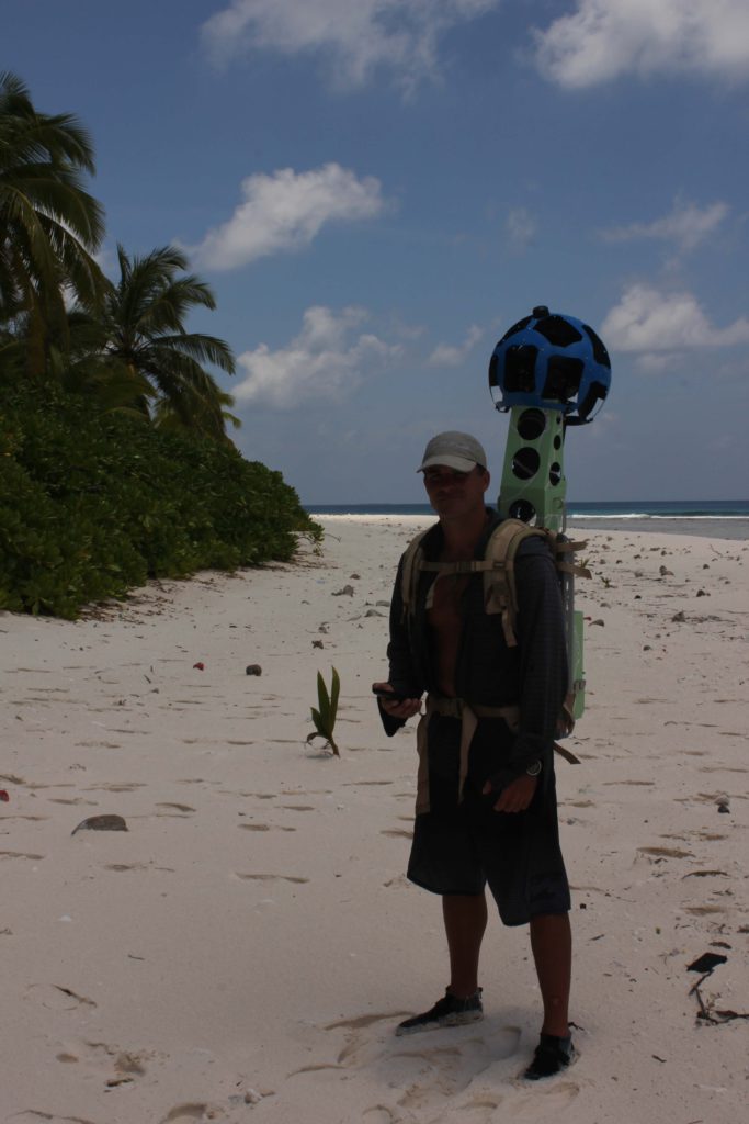
Catlin Seaview Survey and Google Street View
The British Indian Ocean Territory was part of the Catlin Seaview Survey last year. The Catlin Seaview Survey is creating a baseline record of the world’s coral reefs, in high-resolution 360-degree panoramic vision in response to the dramatic decline of the world’s reefs due to pollution, destructive fishing and climate change.
http://catlinseaviewsurvey.com/surveys/indian-ocean/chagos
A Google Trekker unit accompanied the Catlin Seaview Survey team to the British Indian Ocean Territory. The Trekker goes where Google’s StreetView cars can’t go and is responsible for capturing some of the most unique imagery in all of StreetView.
The following are the islands in the British Indian Ocean Territory that have been mapped by the Trekker:
Grande Ile Bois Mangue
This island is important as a bird nesting habitat for seabirds including large colonies of Lesser Noddy and Sooty Tern. The vegetation of the island varies from coconut palms and scaevola shrubs at the edge of the beach to open grassland and hardwood forest in the interior.
Moresby Island
Moresby Island is the northern-most island in the Perhos Banhos Atoll and named after Captain Robert Moresby, who was the first to charter survey the Chagos Archipelago on behalf of the British Admiralty in 1838. His observation on the atoll’s structure were used by Charles Darwin in his 1842 book “The structure and distribution of coral reefs.”
Coin du Mire
Coin du Mire forms a small, rocky plateau a few metres above sea level in the south east of Peros Banhos Atoll. The island is formed of a slab of fossilized coral reef that has been uplifted. This island and Resurgent Island, which has a similar structure and is located on the Great Chagos Bank, are important as the only nesting site in the archipelago for the Masked Booby.
Ile Poule
This is one of the smallest islands of the archipelago and can easily be walked around in a few minutes. Despite this it is still important as a turtle nesting site with nests and turtle tracks evident on its short beaches.
Grande Ile Mapou & Petite Ile Mapou
Grande Ile Mapou and Petite Ile Mapou are two seperate islands but connected by a sand bank that can be walked at low tide.
Ile Fouquet
Ile Fouquet is one of the largest islands of Salomon Atoll. Much of the original vegetation was cleared and given over to the cultivation of coconuts. The interior of the island is now mostly a coconut palm monoculture. This, coupled with the presence of introduced rats, means that the island is not favoured for breeding by seabirds. The wreck of the Black Rose, a large catamaran, can be seen on the northernmost beach where she was grounded as her anchor dragged during a storm.
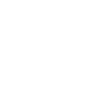
Nelson’s Island
This large island (81 ha) is part of the Great Chagos Bank, the largest coral atoll in the world. The island was designated as an Important Bird Area (IBA) by BirdLife International in 2004 and it has been estimated that 8,300 breeding pairs of Brown Noddy (Anous stolidus) and 13,700 breeding pairs of Lesser Noddy (Anous tenuirostris) inhabit the island during the breeding season.
Danger Island
Danger Island is a large island (6 ha) and is part of the Great Chagos Bank, the largest coral atoll in the world. Designated as an Important Bird Area (IBA) by BirdLife International in 2004 it has been estimated that the island is home to 3,470 breeding pairs of Red-footed Booby (Sula sula) and 11,100 breeding pairs of Brown Noddy (Anous stolidus).
Salomon Atoll
The Salomon atoll consists of 11 separate islands, of which Ile Boddam is the largest and the site of a former coconut plantation. The total land area for the atoll is 3.56 km2
Ile Vache Marine
The British Indian Ocean Territory is an archipelago of 58 tiny islands, of which the largest is Diego Garcia, in over quarter of a million square miles of the world’s cleanest seas. Politically, the archipelago is constituted as the British Indian Ocean Territory (BIOT) and geographically the Chagos Archipelago. Located in the centre of the Indian Ocean, the British Indian Ocean Territory contains the world’s largest coral atoll and the greatest marine biodiversity in the UK by far. It also has one of the healthiest reef systems in the cleanest waters in the world, supporting half the total area of good quality reefs in the Indian Ocean. As a result, the ecosystems of BIOT have so far proven resilient to climate change and environmental disruptions.
Grande Ile Coquillage
Proposed as an Important Bird Area (IBA) by McGowan et al., 2008.
Ile du Sel
Ile du Sel is a tiny island vegetated with a thick forest of coconut palms. In late 2014 the island was the site of a trial to remove introduced rats which should allow seabirds to return and nest. The success of the project will be determined in late 2016.
Ile Jacobin
Similar to Ile du Sel, Ile Jacobin is a tiny island vegetated with a thick forest of coconut palms. In late 2014 the island was the site of a trial to remove introduced rats which should allow seabirds to return and nest. The success of the project will be determined in late 2016.
Ile Parasol
Ile Parasol named for its circular shape, is one of the smaller islands in the Peros Banhos Atoll. Despite its small size it is great importance to ground nesting seabirds such as the Sooty Tern (Onychoprion fuscatus) with an estimate of 14,000 breeding pairs on the 8 ha island in 2004. Designated as an Important Bird Area (IBA) by BirdLife International in 2004.
Ile du Coin
Ile du Coin is the largest island in the Peros Banhos Atoll and the former location of a permanent settlement from where the coconut plantations of the Atoll were run. The island served as the main port for the Atoll and had a jetty from which merchandise was loaded and unloaded. Remains of the jetty can still be seen today.
Sea Cow Island
This medium sized island (18 ha) is part of the Great Chagos Bank, the largest coral atoll in the world. The island was designated as an Important Bird Area (IBA) by BirdLife International in 2004 and it has been estimated that 11,500 breeding pairs of Brown Noddy (Anous stolidus) are present on the island.
East Island
https://www.google.com/maps/streetview/#remote-islands-of-the-world/east-island
Petite Ile Bois Mangue
This small island (9 ha) was designated as an Important Bird Area (IBA) by BirdLife International in 2004. They estimated that the island was home to over 12,000 breeding pairs of Lesser Noddy (Anous tenuirostris).
Petit Ile Coquillage
Proposed as an Important Bird Area (IBA) by McGowan et al., 2008.
Middle Brother
This small island (8 ha) is part of the Great Chagos Bank, the largest coral atoll in the world. The island was designated as an Important Bird Area (IBA) by BirdLife International in 2004 and it has been estimated that 12,500 breeding pairs of Sooty Tern (Onychoprion fuscatus) are present on the island.
Ile de la Passe
Ile de la Passe is the most naturally vegetated island of Salomon Atoll. Being the furthest from Ile Boddam where the historical coconut plantation buildings were established this island escaped coconut cultivation and the introduction of rats. Its vegetation includes hardwood forests, open grasslands, glades of ferns. The island supports a rich population of seabirds.
Nelson’s Island underwater
At this remote island in the northern part of the British Indian Ocean Territory, table corals of varying forms provide an integral coral reef habitat for a variety of reef fishes. Curious tawny nurse sharks and black trevallies swim by, but can sometimes be difficult to spot through the clouds of bait fishes obscuring the water column. Image collect by Catlin Seaview Survey.